News and Notes on the
|
Or What could be the future
|
|
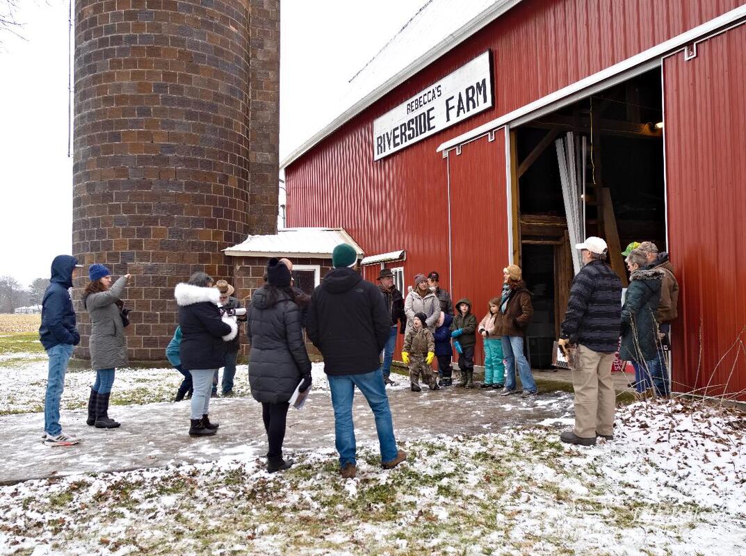
2/5/2023 Michigan economic development corporation (MEDC) plans to tear down historic farmsteads in marshall megasiteRead NowMedc has claimed since 2019 that the "Marshall megasite" is "vacant" property with no existing structures. That is False.The Michigan Economic Development Corporation has claimed since 2019, that the land which makes up the Marshall Megasite is vacant agricultural land, void of any structures. This is a falsehood The 1,800 acre site is comprised of hundreds of individual property which range from small ranch houses to historic 120 year old farmsteads. One of these, Riverside Farm, dates back to the late 1800's. The farm is a showpiece, with principle hay barn, attached horse stalls, milking barn, cattle barn, hog barn, corn crib, machine shed, garage and two granaries. The farm, which was farmed through October 2022, is located at 13024 C Drive North. The following Reconnaissance Survey of History was made By Ina Hanel-Gerdenich dated February 5, 2023 The scope of this survey is to review the readily available literature online to determine the ownership and other history of the indicated property. The results from this brief survey are included below. The property lies in Section 29 of Marshall Township (T2S R6W) and is currently described as the SW ¼ of the section except the “E 91 feet of N 338 feet, totaling 159.29 acres.”1 The farm buildings are grouped together near the northwest corner of the property. They include a nineteenth century house and late nineteenth- and early to mid-twentieth-century barns and outbuildings. For clarity, the descriptions below refer to three parcels: A, B, and C. Parcel A consists of the W ½ of the SW ¼ (80 acres) of Section 29 and includes all the extant buildings standing in its northwestern corner. Parcel B refers to the E ½ of the SE ¼ (76 acres) in the neighboring Section 30 to the west. Parcel C refers to the 80-acre parcel to the east of Parcel A, described as the E½ of the SW ¼, Section 29. All three parcels are currently owned by Phillip Glotfelty III. The farm was established on the north shore of the Kalamazoo River, a few miles west of the city of Marshall and a few miles south of Michigan Ave and I-94 (the former Territorial Road corridor). The location was central to transportation—not only was it nearby to the major roads, it also was situated between the railroad stops in the towns of Marshall and Ceresco. The crossroads concept can be applied to other aspects of local history. The area around Battle Creek and Marshall was associated with the Underground Railroad during the mid-nineteenth century. Prior to that, the early surveyors recorded an “old Indian Village” on the banks of the Kalamazoo river, about one mile east of the farm.2 By the second half of the nineteenth century, most of the local area that was originally forested (and included oak openings) had been cleared and developed into farmland, and the local 1 Marshall Township, Calhoun County, Tax Assessor page, 2/3/2023. 2 Plat Image of Original Survey of Marshall Township by Lucius Lyons, October 1825. General Land Office Records, https://glorecords.blm.gov/, accessed 2/3/2023. towns and cities were firmly established with businesses providing the necessary goods and services. Nearby Marshall was well established, serving as the county seat since 1838. The following provides a snapshot of property ownership during specific years. The years selected are those in which a historic plat map of the area is available.3 1858: The property now owned by Thomas Knight included the NW ¼ of the SW ¼ of Section 29 (northern half of Parcel A, 40 acres) and the neighboring 76 acres in Section 30 (Parcel B). Thomas Knight (1805-1892) was an early settler of Marshall Township, arriving in 1831 or 1832 from England and buying parcels of land as early as 1833. 4 The 1840 census indicates that he was in the agriculture business. He lived in Section 18 with his wife and ten children, but owned land in Sections 19 and the NW ¼ of the NW ¼ in Section 29 in addition to the northern half of parcel A and parcel B. By 1870, Knight owned 400 acres in the area. He had served as one of two Township coroners in 1865- 1866. He also was a highway commissioner and township assessor at various times. In 1872 he moved to Section 13 in neighboring Emmet Township and his son occupied the father’s former property in Section 18. Thomas owned up to 500 acres in both townships in his later life. It is not clear if the Riverside Farm property (or any of the other scattered parcels owned by Thomas Knight) was farmed during this time or simply kept vacant. There are no buildings indicated on Parcels A, B or C on the 1858 plat map. The railroad tracks had been installed (Michigan Central RR arrived in Marshall in 1844), cutting across Parcel B and clipping the southwestern corner of Parcel A. The town of Ceresco a few miles to the west was established in 1838 and had grown to include a church, two schools, hotel, merchants, several mills, shoe shop and shoemaker.5 1873: By this time, the farm was owned by John and Frances Carnes Shea. It consisted of Parcels A and B (the W ½ of the SW ¼ of Section 29 and the E ½ of the SE ¼ of Section 30). A house is indicated near the northwest corner of Parcel A. Parcel B includes two adjacent houses placed along the west side of the current U-shaped driveway and due west of the house in Parcel A. Neighbor George Avery owned the E ½ of the SW ¼ in Section 29 (Parcel C, 80 acres), and his house was located near the northeast corner of his parcel. John Shea was born in County Cork, Ireland in 1837. He emigrated to New York in about 1851 when he was fourteen years old. While working in New York City, he met his wife Frances. They were married in 1866 and their first child, Agnes, was born in New York in 1868. Sometime between 1868 and 1871 (when the next child was born in Michigan), the young family moved to Marshall, and by 1873 settled on the farm. Given these dates and the appearance of a house symbol on the 1873 plat map, it is possible that the Sheas were the ones to build the east wing of the house, which appears to be older than the west wing.6 The 1880 Agricultural census records indicate that the Sheas had a typical farm of the area—one that was smaller in size and profit than many others, but by no means the smallest or poorest. There are two unusual features of the Shea farm in 1880: the family did not raise sheep, but instead raised a slightly larger number of swine and chickens. They also planted sixteen acres of potatoes during the census year. This contrasts with the surrounding farms which typically planted one-half to one acre of potatoes. John Shea’s father (also John Shea) and younger brother Jeremiah immigrated later with additional family members and settled in Marshall township as well. In about 1883 (possibly by 1882 or as late as 1884), the Shea Family sold the farm and moved to Kingston County, Kansas. John had traveled there to help settle an estate for a Michigan neighbor and liked it so much that he decided to stay. He purchased a farm there as well, although a son later remarked that he “was no farmer.” From 1899-1903 John was elected as a judge. He died in 1921. 1884: The farm as indicated on the plat map from this year is owned by Charles D. Brewer. Charles was the son of Chauncey M. Brewer, an early settler of Marshall from New York. Chauncey established a dry goods store in the town in 1836 which was passed to his sons, Charles D. and Edgar M. in 1875. Chauncey would become one of the wealthiest and respected men in the county.7 Charles Brewer was born in Marshall in 1850. He married Anna M. DeWolfe in 1878 and had three children born between 1881 and 1886. In 1900, Charles sold his share of the store to his brother, and focused his energies on managing his multiple farms, which had grown to a combined total of 1000 acres at the time. 8 The Riverside Farm was a part of this larger operation. Charles and his family had moved to Ward 2 in the City of Marshall, and he is listed as working as a “capitalist” in that year’s census. Charles died there in 1922. His occupation at the time was described as “merchant.” It is not known who was working on the Riverside farm property during this time. Charles leased his farms on a share basis. However, he may have been the one to build (or commission) the hip-roofed portion of the house on the west side as well as some of 6 Interpretation of relative construction dates are made from online photographs only (no site visit). Note that the west wing is capped by a hipped roof rather than a gable roof. What is unusual is that the hipped roof has very low eaves, leaving no room for a frieze, suggesting a later construction date. the farm’s outbuildings during the 1880s and later. The west wing may have been built as late as the 1920s.9 An undated plat map probably from the late nineteenth or early twentieth century continues to show three houses (two on Parcel B and one on Parcel A) clustered around the driveway that runs along the boundary between the two parcels. 1916: According to the plat map of this year, the farm was still owned by Charles D Brewer. It included all 160 acres in Section 29 (Parcels A and C) and approximately 78 acres in Section 30 (Parcel B). The house in Section 29 (Parcel A) is indicated, but the two houses in Section 30 (Parcel B) appear to have been removed. Charles is not included on the list of Farmers published in the Farm Journal’s Rural Directory of Calhoun County (1916). 1920s-1960s. It is not known who owned the Riverside Farm during these decades,10 but the buildings depicted in the photographs indicate that a dairy operation was conducted. The ceramic tile silo probably dates to the 1920s. The drive-through corn crib may date to the post World War II period. Other outbuildings and the addition to the main barn may have been built during this time as well. 1974: The farm purchased by Philip III and Marlene Glotfelty in 1974 (Parcels A, B, and C) The farm was continually leased to local farmers through October of 2022. The Glotfelty family operated a hobby farm with goats, chickens, horses, pigeons, pheasants. The family planted 10,000 white pine along the Kalamazoo River circa 1974 and 1975. The Marshall Area Economic Development Alliance is set to close on the property in February 2023. The family will be made to torn down the property for the Marshall Megasite. Additional research can be conducted to determine more of the twentieth-century history of Riverside Farm. Twentieth-century census records, directories, Rockford Plat maps, and deed records (is there an Abstract in the possession of the family?) have not been examined. In addition, descendants of the Shea and Brewer families may have information, and a survey of the buildings on the property may reveal clues. References Atlas of Calhoun County, Michigan. New York: F.W. Beers and Company, 1873. Farm Journal Illustrated Rural Directory of Calhoun County, Michigan. Philadelphia: Wilmer Atkinson Company, Publishers, 1916. Gardner, Washington. A History of Calhoun County, Michigan. Chicago: Lewis Publishing Company, 1913. 9 The farm as depicted in an undated older framed photograph in the possession of the Glotfelty family shows the house without the west wing. 10 A review of the 1920 United States Population census for Marshall Township revealed no obvious clues. Charles Brower is listed as living on Prospect Street in the city of Marshall. History of Calhoun County, Michigan. Philadelphia: L. H. Everts, 1877. Lyons, Lucius. Marshall Township Surveyor Notes, October 1825. General Land Office Records, https://glorecords.blm.gov/, accessed 2/3/2023. Map of Calhoun County, Michigan. Philadelphia: Geil, Harby and Siverd, 1858. Plat Map of Calhoun County, nd. (familysearch.org/library/books/). Standard Atlas of Calhoun County. Chicago: George A. Ogle and Co., 1916. United States Census Bureau. Federal Census Records, Calhoun County, Michigan. Schedule 1: Population Schedule, Marshall Township, 1840, 1850, 1860, 1870, 1880, 1900. United States Census Bureau. Federal Census Records, Calhoun County, Michigan. Schedule 2: Agriculture Schedule, Marshall Township, 1880. Prepared by: Ina Hanel-Gerdenich Mirka Productions, LLC Ann Arbor, Michigan 734-717-9079 February 5, 2023 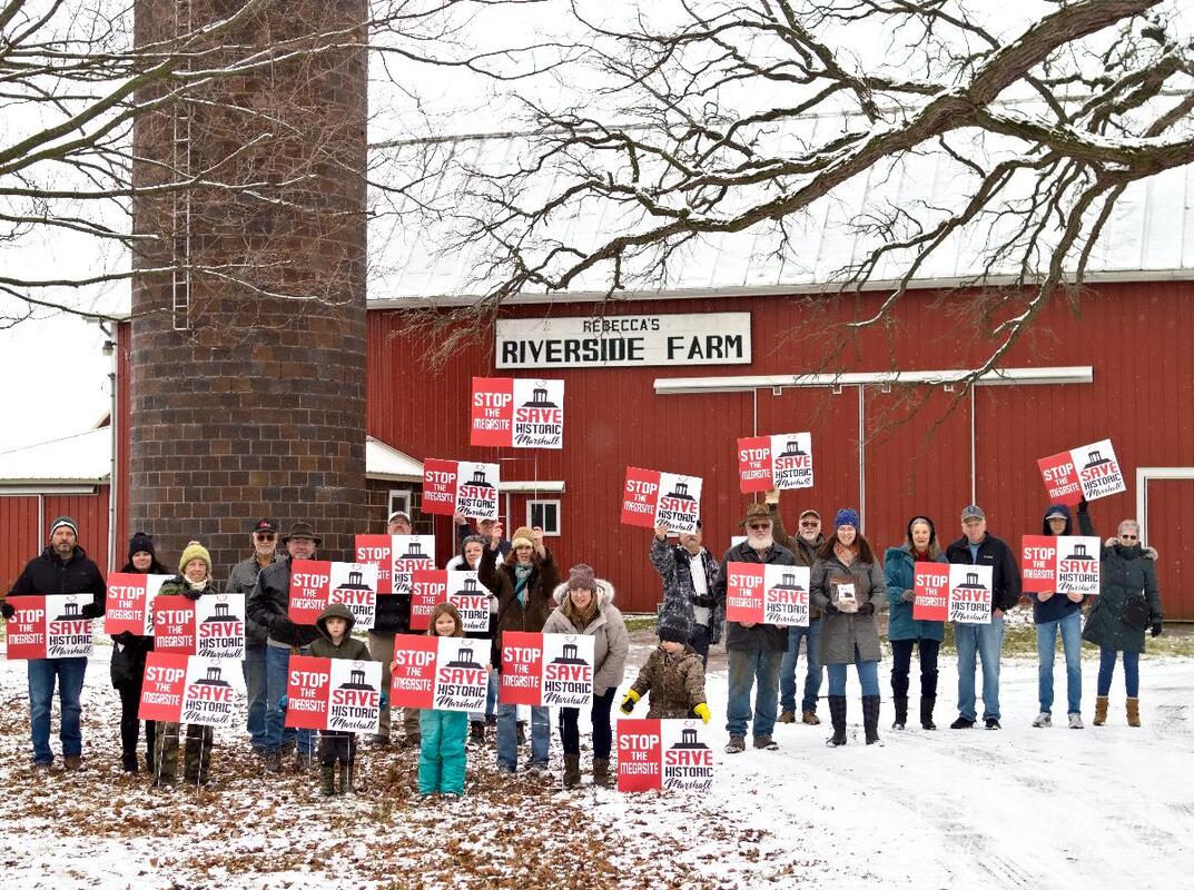
0 Comments
Leave a Reply. |
Concerned CitizensWe are concerned residents who are oppossed to the State of Michigan's plant to create a 1,600 acre industrial park outside historic Marshall, Michigan. Instead we wish to see a 1,600 acre recreational area on this site which runs along two miles of the Kalamazoo River. Save Historic Marshall, Save Michigan's Agricultural Land and Protect Michigan's green spaces! Archives
May 2023
Categories |


 RSS Feed